There are very few trail markers in Soapstone Valley. My guide will help you through …
***
SOAPSTONE VALLEY TRAIL: MY MAP | TIPS | CONNECTIONS | NEARBY
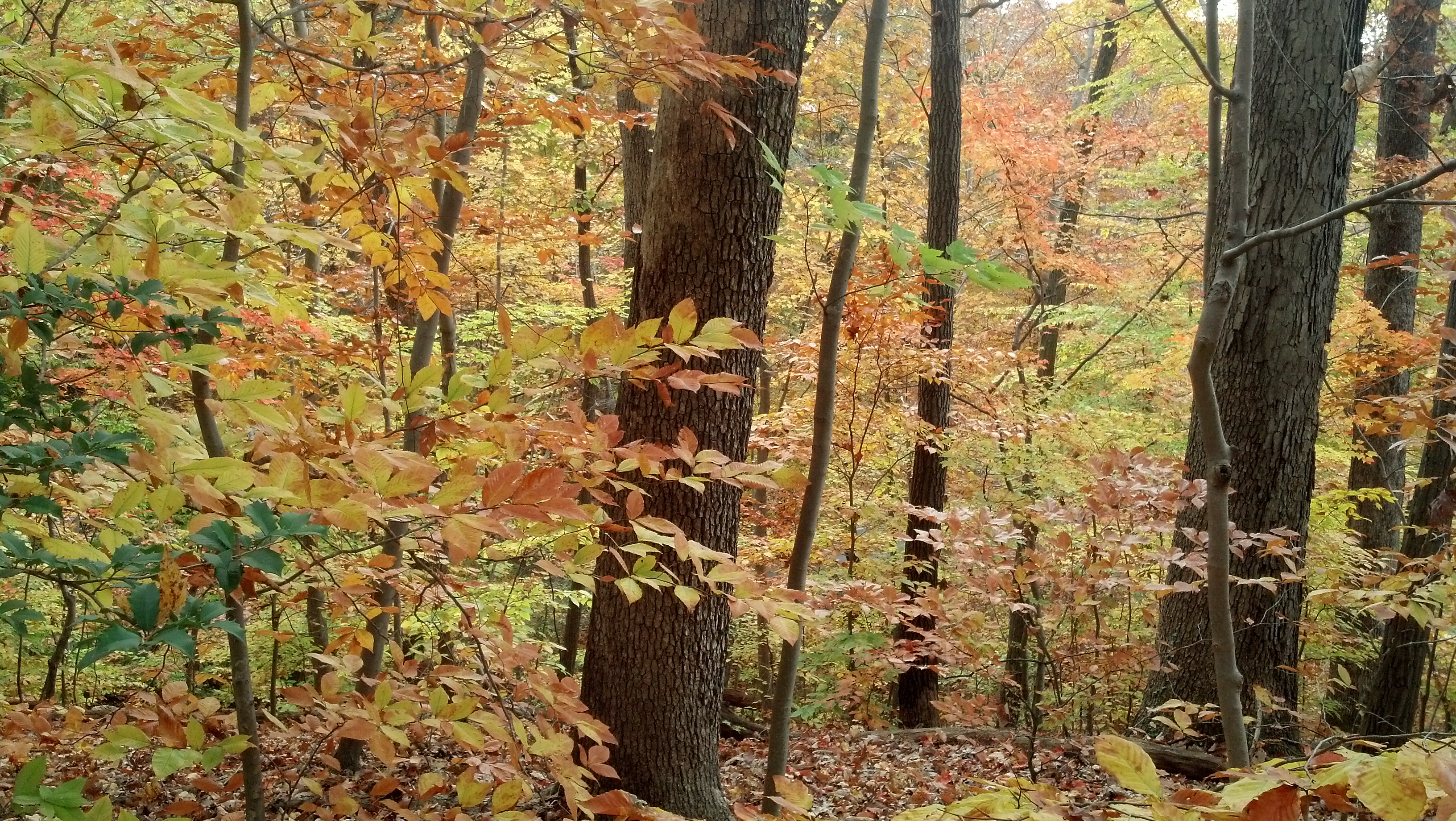
During one of my Soapstone Valley hikes in November, I encountered an older Asian woman on the path linking one of the western trailheads and the main route along the creek. She had just descended a somewhat steep ridge and was looking downstream. The floor of the valley was covered in bright-colored autumn leaves.
Is this the right way?
She asked me if she was on the right path to Rock Creek Park. She was. But I could tell that she was evaluating whether to venture onward.
“Is the path difficult to follow?” the woman, who spoke with an accent, asked, pointing to all the leaves on the ground.
“See the yellow marks on the trees?” I asked her, pointing to a nearby tree trunk. “Those mark the path.”
Her concern was warranted. I explained the basic topographical elements of the roughly mile-long trail, which are helpful for anyone venturing into Soapstone Valley. It’s not treacherous by any stretch of the imagine but at certain points, the path through Soapstone is not necessarily an easy route, especially those who might be expecting a level path.
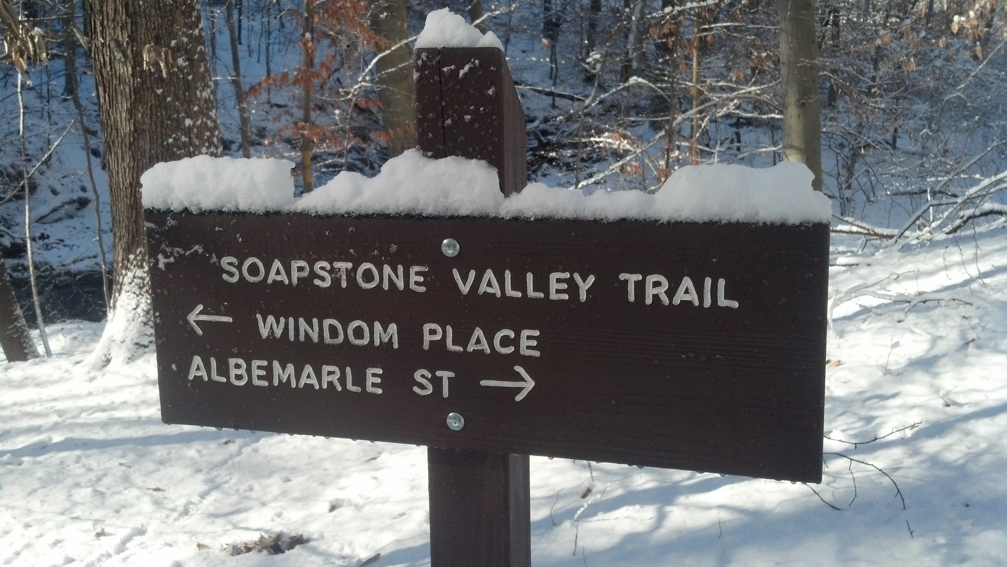
- Soapstone Valley’s western trailheads near Connecticut Avenue are located at Albemarle Street NW near 32nd Street and Windom Place NW near the Calvert-Woodley Fine Wines and Spirits. (SEE MY MAP.)
- The main section of the trail crosses Soapstone’s creek seven times. There’s an additional crossing on the connector path linking the main path to the Windom Place trailhead.
- Going to/from Soapstone Valley’s eastern trailhead from Rock Creek Park‘s Western Ridge Trail or Beach Drive requires walking along a short section of Broad Branch Road. Heading downstream (eastbound), make a right turn (south) at Broad Branch. Road, which lacks a sidewalk or wide shoulder. Be aware of vehicular traffic.
- Audubon Terrace NW, a paved dead-end residential lane, runs along the northern ridge of Soapstone Valley. It connects different sections of the trail and provides an easy bypass of four of the creek crossings. This is a popular street for neighborhood dogwalkers.
- Heading westbound (upstream) from the Broad Branch Road trailhead, the trail will eventually emerge at Audubon Terrace NW’s eastern end. To continue on the trail, look for a staircase at left (south). To continue to the Albemarle Street trailhead, continue uphill along Audubon Terrace.
- High water can sometimes make crossing the creek difficult (or impossible). Proceed with caution, especially immediately after sustained periods of rainfall or snowmelt. Rocks can often be slick and fallen leaves in the late fall and winter can be slippery, especially on hillsides or steep terrain.
- Soapstone Valley Trail is a footpath. The National Park Service, which oversees a majority of Soapstone Valley, prohibits bicycles on the trail (and for good reason considering all the creek crossings). Other NPS rules and regulations apply to the trail and adjacent federal parkland.
- There are no campgrounds or picnic areas in Soapstone Valley but the large rocks near Main Trail Crossing No. 4 can a nice place to sit on a sunny day. (SEE MY MAP).
My Soapstone Valley Guide continues below …
TRAIL CONNECTIONS: There are no direct trail connections between the Soapstone Valley Trail and other footpaths in Rock Creek Park. The Western Ridge Trail, which runs to the east of Broad Branch Road, is a short walk from Soapstone Valley’s eastern trailhead. The Theodore Roosevelt Side Trail and Valley Trail are nearby too.
Trailheads to other federal parklands in Upper Northwest D.C. are within a 15-25 minute walk of Soapstone Valley’s western trailheads near Connecticut Avenue. The Melvin Hazen Trail‘s western trailhead is at Reno Road & Tilden Street NW and crosses Connecticut Avenue near Rodman Street.
The Glover Archbold Trail, Upper Northwest D.C.’s primary north-south footpath, runs between the Potomac River near Georgetown to Van Ness Street NW. Its northern trailhead at 40th Place NW & Van Ness Street.
WHAT’S NEARBY: Soapstone Valley’s western trailheads are located just east of Connecticut Avenue. The Van Ness-UDC Metrorail Station (at Connecticut Avenue & Veazey Terrace NW) is a short walk from the Windom Place NW trailhead (adjacent to Calvery-Woodley Fine Wines & Spirits. The L1/L2 Metrobuses stop at Connecticut Avenue & Albemarle Street NW and the Van Ness-UDC station.
On-street parking is usually available on the eastern end of Audubon Terrace NW but not the western end, where the right-of-way is narrow and close to the ridge edge.
Parking lots adjacent to Rock Creek Park’s historic Pierce Mill, which is within a 5-10 minute walk of Soapstone Valley’s eastern trailhead at Broad Branch Road. The mill is a Rock Creek Park landmark and is open for tours.
Howard University Law School (2900 Van Ness St. NW), the Netherlands Embassy and Hillwood Museum and Gardens (both located along the southern section of Linnean Avenue NW) all border Soapstone Valley but are not immediately accessible from the Soapstone Valley Trail itself.
The University of the District of Columbia’s Van Ness Campus, including the David A. Clarke Law School, Van Ness Center and embassies along International Drive are clustered around the Van Ness-UDC Metrorail Station.
The area immediately around the Van Ness station along Connecticut Avenue NW isn’t necessarily known for incredibly interesting dining and shopping amenities. But the basics are all within a short walk of Soapstone Valley’s western trailheads. Giant Foods (4303 Connecticut Ave.), Starbucks (4250 Connecticut Ave.), Potbelly Sandwich Shop (4300 Connecticut Ave.), Subway (4401 Connecticut Ave.), Burger King (4422 Connecticut Ave.), Walgreen’s (4225 Connecticut Ave.) and CVS Pharmacy (4309 Connecticut Ave.) are there, along with Calvert-Woodley Fine Wines & Spirits (4339 Connecticut Ave.), a local landmark known for its pre-holiday and weekend traffic congestion.
Noted local breadmaker Mark Furstenberg will be opening Bread Furst in the winter of 2014 on the west side of Connecticut Avenue, just south of Albemarle Street NW next to the Flagship Car Wash Center. A branch of Pho 14 is located on east side of Connecticut Avenue between Veazey Terrace NW and Van Ness Street NW.
UDC’s farmers market is held on Saturdays in the spring, summer and fall is located at Connecticut Avenue & Yuma Street NW, outside the David A. Clarke School of Law.
OTHER SOAPSTONE VALLEY LINKS:
Trailrunner | Core 72 | Sierra Club